
in the signofVicino
Nature Reserve
of Mount Casoli
The Monte Casoli Nature Reserve was established by Lazio Regional Law no. 30 of 1999. The managing body is the Province of Viterbo in collaboration with the Municipality of Bomarzo. The Reserve, 285 hectares and entirely within the municipality of Bomarzo, was established in order to promote the conservation and enhancement of the territory and natural and cultural resources and to protect and recover natural habitats including animal and plant species. It is also intended to promote the economic and social development of local communities and to use environmental resources for educational and recreational purposes.
The Reserve’s striking tufa plateau of volcanic origin was created over the millennia by the digging action of the Sodere watercourses to the south and Vezza to the north. It is reached by a partly unpaved road that starts from the historic center of Bomarzo, following the signs for the “Monster Park” and passing its entrance, about 2.5 km from the village by a driveway to the vicinity of the small church of Santa Maria di Monte Casoli, of medieval layout expanded in the 16th century. The remains of a castle, walls of squared blocks of tufa and defensive moats, possibly from Etruscan times, are visible on the high ground.
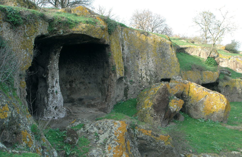
Among a dense oak forest are numerous cavities dug by man over the centuries. Their typology is often similar: quadrangular rooms with docks on either side, with clear signs of reuse (small windows, feeders, recesses for conversion to sheepfolds or stables). It is unclear whether these might originally have been Etruscan tombs.
What is certain is that Monte Casoli, similar to other centers on tuffaceous high ground in upper Latium, was fortified in conjunction with Roman expansion, abandoned following conquest and reoccupied in the Middle Ages again for defensive reasons.
What makes the protected area of Mount Casoli a jewel of our region is the simultaneous presence of important environmental values and numerous archaeological remains. In fact, areas of Etruscan and Roman necropolis, rock-cut dwellings, and rock altars are visible among the dense vegetation and volcanic cliffs overlooking waterways.
A recent study of the environmental characteristics of our region showed that the environment of the Bomarzo area is among the most pristine: this is evidenced by the presence of certain species of lichens. In the Reserve’s forests, it is rare to observe large trees, as logging was carried out until shortly before the establishment of the protected area.


Reserve Logo
Bomarzo’s Monte Casoli Reserve, established in 1999 and now known for its natural and archaeological beauty, now also has an identifying logo.
For its realization, the Associated Studio Ala Ricerche of Barbarano Romano took into consideration three main themes: the first, concerning the naturalistic aspect, was expressed through the symbol of a green turkey oak leaf; the second, the depiction of the deep hollows of Monte Casoli, was obtained by breaking down half of the leaf page into a “negative” so as to create tunnels within the third element: the fortress on which the ancient Polimartium stood.
The latter theme, which is clearly historical in nature, is based on the depiction of the country offered by the fresco in the Sala Regia of the Palazzo Comunale in Viterbo. The color chosen for the shape of the ancient village (a nuance between brown and red), in addition to evoking the tufa and the soils of these places, is in perfect harmony with the graphic choices brought forward by the Lazio Region, which has designated it as the main shade of the Protected Areas System.
Behind the Fortress rises a shining sun, a symbol of rebirth and renewal: in fact, the area feels the profound need to make the most of its many resources, overcoming the now obvious identification with the Monster Park alone.


Mugnano in Teverina
About 4 km A few kilometers from Bomarzo is Mugnano in Teverina, a small hamlet located on high ground close to the Tiber and its valley at 133 m above sea level and inhabited by nearly 100 people.
Similar to other centers of the Teverina, the original Etruscan settlement developed on the plateau of an easily defensible tuffaceous spur, made even more protected by a deep moat that still divides the plateau into two distinct parts, the outermost of which was inhabited only in modern times.